June 2026 was quite a bit warmer than average, with northern sections wetter than average, while southern areas had near average rainfall. The average temperature was 67.8 degrees, about 4 degrees above average, making it the 8th warmest June on record. Daytime high temperatures and nighttime low readings were both equally above average during the month.
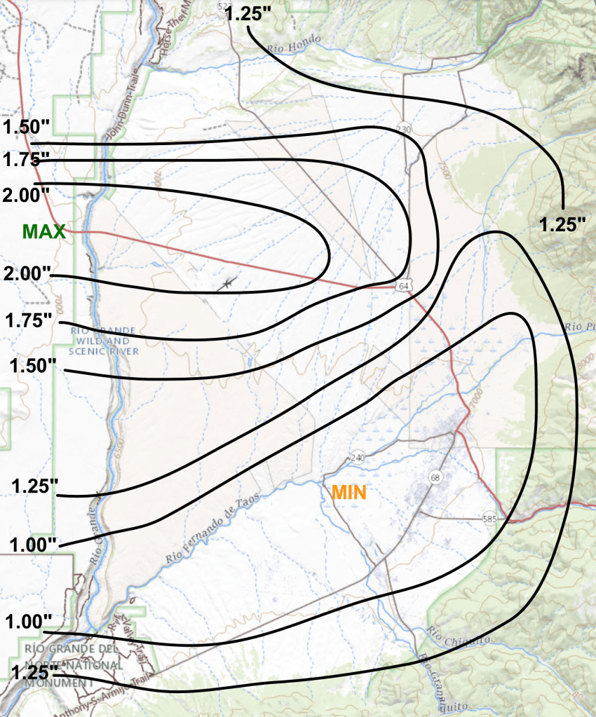
As for rain across the valley, localized showers occurred during the month, with more of them moving across the northern sections than in the south. At my northside location rainfall totaled 1.98 inches for the month, over an inch above average (usual June rainfall is 0.88″), while southern areas received rainfall that was around 0.75 to 0.95 inches (see rainfall map below).
The month started out quite warm with above average temperatures through the first two weeks as highs were in the 80s to around 90. Some showers moved through the area mainly on the 3rd. A welcome but brief period of cooler and wetter weather occurred on the 13th to the 15th with another round of showers and highs in the 70s. Quite warm weather quickly returned during the third week, and lasted through the end of the month with highs in the low 80s to low 90s, and lows of 45 to 55. Another day of showers occurred on the 26th.
The warmest high was 93 degrees on the 17th, 18th, and 23rd, while the coldest high was 76 degrees on the 15th. The coldest low was 41 degrees on the 1st, while the warmest low was 57 degrees on the 29th. The high of 93 on the 18th tied the record warm high for that date.
Overall, wind speeds for the month were a little above average, with 20 days recording peak wind gusts of 35 mph or higher. Strongest overall winds occurred on the 2nd, 14th, 28th and 29th, while the highest gust of 52 mph was measured on the 9th.
Here are the actual numbers for the month at my location…
Average Temp . . . . 67.8 degrees, +4.0 degrees above average (8th warmest)
Average High . . . . . 86.2 degrees, +4.6 degrees above average (10th warmest)
Average Low. . . . . . 49.4 degrees, +3.5 degrees above average (11th warmest)
Total Rain . . . . . . . 1.98 inches, +1.10 inches above average
June 2026 rainfall totals (from rain gauges)
JUN 2026 DAILY DATA for 4 NNW Taos
| DATE | HIGH | LOW | DAILY DEP. | MON. DEP. | RAIN | REMARK |
| 1 | 85 | 41 | +4.2 | +4.2 | ||
| 2 | 82 | 48 | +5.6 | +4.9 | T | |
| 3 | 81 | 46 | +3.7 | +4.5 | 0.61″ | 1/8-1/4″ hail 304-317 PM |
| 4 | 81 | 44 | +2.6 | +4.0 | ||
| 5 | 85 | 48 | +6.0 | +4.4 | T | |
| 6 | 84 | 48 | +4.5 | +4.4 | 0.01″ | |
| 7 | 83 | 45 | +2.7 | +4.2 | ||
| 8 | 87 | 48 | +6.0 | +4.4 | ||
| 9 | 85 | 51 | +6.3 | +4.6 | T | |
| 10 | 88 | 48 | +6.0 | +4.8 | ||
| 11 | 90 | 47 | +6.0 | +4.9 | ||
| 12 | 89 | 52 | +7.7 | +5.1 | T | |
| 13 | 85 | 56 | +7.5 | +5.3 | 0.07″ | |
| 14 | 79 | 53 | +2.4 | +5.1 | 0.24″ | |
| 15 | 76 | 48 | -1.8 | +4.6 | 0.31″ | 1/4-3/8″ hail 124-131 PM |
| 16 | 88 | 45 | +2.5 | +4.5 | ||
| 17 | 93 | 46 | +5.0 | +4.5 | ||
| 18 | 93* | 51 | +7.2 | +4.7 | 0.09″ | *Tied record warm high |
| 19 | 88 | 54 | +6.0 | +4.7 | 0.01″ | |
| 20 | 90 | 54 | +6.5 | +4.8 | ||
| 21 | 89 | 46 | +1.6 | +4.7 | ||
| 22 | 89 | 46 | +1.8 | +4.5 | ||
| 23 | 93 | 50 | +5.5 | +4.6 | ||
| 24 | 92 | 53 | +5.7 | +4.6 | 0.01″ | |
| 25 | 84 | 56 | +3.6 | +4.6 | T | |
| 26 | 87 | 51 | +2.3 | +4.5 | 0.57″ | 1/4″ hail 541-547 PM |
| 27 | 84 | 48 | -1.0 | +4.3 | ||
| 28 | 87 | 55 | +3.3 | +4.3 | ||
| 29 | 83 | 57 | +2.5 | +4.2 | ||
| 30 | 86 | 47 | -0.7 | +4.0 | 0.06″ | |
| AVGS/ TOTAL | 86.2 | 49.4 | 67.8 | +4.0 | 1.98″ |
DAILY DEP. – Departure from the long term daily average temperature
MON. DEP. – Cumulative departure from the long term monthly average temperature
T – Trace of rain
—————————————————————————————————-

