It was quite a bit warmer than average in July 2026, along with below average rain. The monthly average temperature was 72.0 degrees, about 4 degrees above average, making it the 4th warmest July on record. Daytime high temperatures and nighttime low readings were both equally above average, especially in the final 2 weeks of the month.
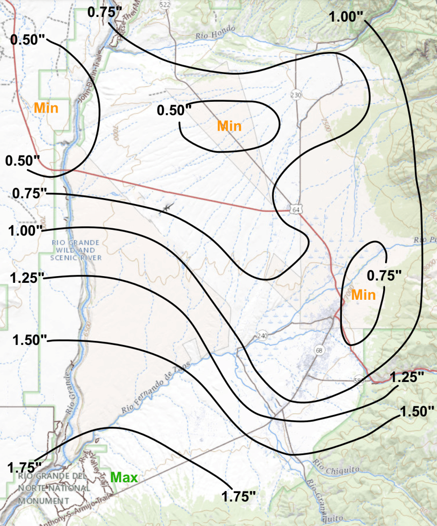
Rainfall during the month once again was below average across the valley. At my northside location rainfall totaled 0.86 inches for the month, over 3/4 of an inch below average (usual July rainfall is 1.71″). More rain did however fall across the far southern and southwest parts of the valley (mainly on the 22nd and the 31st), where amounts reached up to around 1.50 inches (see rainfall map below).
The month started out warm with a bit above average temperatures through the first week as highs were in the mid to upper 80s with lows in the upper 40s to mid 50s. The first hot spell of the month started in the second week, with 5 days in a row with highs of 90 or above from the 8th to the 12th, but at least it cooled off at night with lows of 50 to 55. Some weak monsoon moisture seeped into the area for some late day showers and cooler readings from the 13th to the 19th, as highs dropped a bit into the mid to upper 80s.
Then the real hot weather settled into the region for the last 10 days of the month. Except for some mid 80s on the 22nd and 23rd with late day showers, highs were in the low to mid 90s, including a stretch of 8 days in a row with highs of 90 or above. Overnight lows however were quite warm, with readings in the upper 50s to low 60s during this time. Some more showers occurred on the 25th, 26th and 31st.
The warmest high was 95 degrees on the 26th and 30th (a record warm high on the 30th), while the coolest high was 81 degrees on the 16th. The coolest low was 44 degrees on the 4th, while the warmest low was 61 degrees on the 25th. Daily records for the warmest overnight low were set on the 11th, 25th, and 28th.
There were also 15 days in July with highs of 90 degrees or more, which was the 7th most on record.
Overall, wind speeds for the month were about average, with 12 days recording peak wind gusts of 35 mph or higher. Strongest overall winds occurred on the 11th, 12th, 21st and 31st, while the highest gust of 51 mph was measured on the 11th.
Here are the actual numbers for the month at my location…
Average Temp . . . . 72.0 degrees, +4.0 degrees above average (4th warmest)
Average High . . . . . 89.5 degrees, +4.8 degrees above average (6th warmest)
Average Low. . . . . . 54.6 degrees, +3.3 degrees above average (5th warmest)
Total Rain . . . . . . . 0.86 inches, -0.85 inches below average
JULY 2026 rainfall totals (from rain gauges)
JUL 2026 DAILY DATA for 4 NNW Taos
| DATE | HIGH | LOW | DAILY DEP. | MON. DEP. | RAIN | REMARK |
| 1 | 85 | 51 | +0.8 | +0.8 | ||
| 2 | 86 | 52 | +1.6 | +1.2 | ||
| 3 | 87 | 48 | +0.2 | +0.9 | ||
| 4 | 88 | 44 | -1.5 | +0.3 | ||
| 5 | 89 | 55 | +4.6 | +1.1 | ||
| 6 | 89 | 51 | +2.1 | +1.3 | ||
| 7 | 89 | 53 | +3.3 | +1.6 | ||
| 8 | 91 | 54 | +4.4 | +1.9 | ||
| 9 | 92 | 53 | +4.9 | +2.3 | T | |
| 10 | 93 | 52 | +4.0 | +2.4 | ||
| 11 | 93 | 60* | +8.0 | +2.9 | *Record warm low | |
| 12 | 92 | 52 | +3.5 | +3.0 | ||
| 13 | 89 | 54 | +3.2 | +3.0 | 0.16″ | |
| 14 | 84 | 54 | +0.8 | +2.8 | 0.07″ | |
| 15 | 84 | 51 | -1.1 | +2.6 | T | |
| 16 | 81 | 52 | -2.2 | +2.3 | T | |
| 17 | 85 | 53 | +0.6 | +2.2 | 0.10″ | |
| 18 | 88 | 49 | +0.2 | +2.1 | 0.14″ | |
| 19 | 89 | 53 | +3.1 | +2.1 | T | |
| 20 | 94 | 59 | +8.2 | +2.4 | ||
| 21 | 91 | 59 | +6.7 | +2.6 | ||
| 22 | 86 | 57 | +3.8 | +2.7 | 0.10″ | |
| 23 | 85 | 58 | +3.6 | +2.7 | T | |
| 24 | 92 | 56 | +6.3 | +2.9 | ||
| 25 | 92 | 61* | +8.7 | +3.1 | 0.26″ | *Record warm low |
| 26 | 95 | 57 | +8.1 | +3.3 | 0.01″ | |
| 27 | 93 | 57 | +7.5 | +3.4 | ||
| 28 | 90 | 60* | +7.5 | +3.6 | *Record warm low | |
| 29 | 93 | 59 | +7.8 | +3.7 | ||
| 30 | 95* | 59 | +8.8 | +3.9 | *Record warm high | |
| 31 | 93 | 59 | +8.0 | +4.0 | 0.02″ | |
| AVGS/ TOTAL | 89.5 | 54.6 | 72.0 | +4.0 | 0.86″ |
DAILY DEP. – Departure from the long term daily average temperature
MON. DEP. – Cumulative departure from the long term monthly average temperature
T – Trace of rain
—————————————————————————————————-

